Author Archives: bcpoa

Possible Cell Tower Appearance

Update: Atlas Towers’ renditions are at http://zoning.posterous.com/atlas-cell-tower-mockups

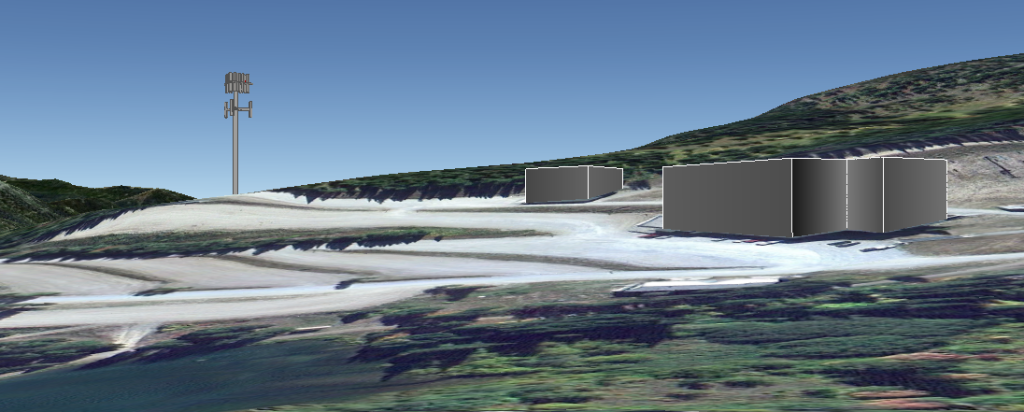
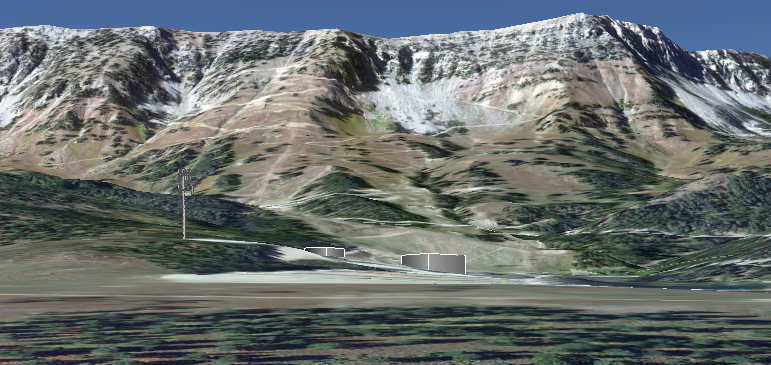
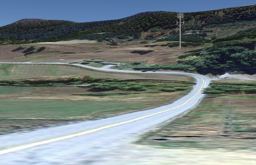
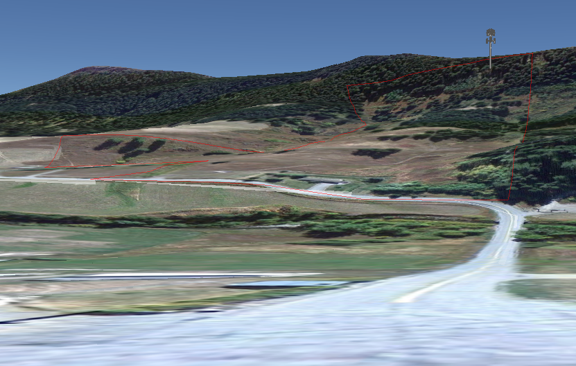
Here are some very rough renderings of cell towers at locations currently under discussion. Bear in mind that these are probably worst-case, as tower heights are likely to be lower. The renderings do not represent tree cover, which would reduce the appearance of height, though neither location offers dense tree cover. A stealth tower design and smaller antenna arrays could also reduce the visual impact.

“Bridger Ski” tower

Bridger Bowl, with a 130′ tower just south of the propane tank in A lot. Very rough envelopes of the Saddle Peak lodge and ski patrol building shown for scale.

As seen from Bridger Pines, looking across the base area:

BridgerSkiFromBP

As seen from the entrance off Hwy 86:

BridgerSkiFromEntry

“Bridger South” tower

A 150′ tower on the Brunner property, at the bottom of Kelly Canyon. I placed this about halfway upslope on the narrow parcel, though the actual location is not known to me.

From the Schoolhouse:

BridgerSouthFromSchoolhouse

From Kelly Canyon at the Bridger Woods Rd. turnoff:

BridgerSouthFromKellyBW

Bridger South – Taller

Update: There are conflicting reports about the location of the South tower needed for connectivity. If the tower would have to be tall enough to see over the ridge to the south, it would look more like the following:

BridgerSouthFromSchoolhouse2

Tree cover would conceal the bottom portion of the tower, possibly diminishing the impression of height. But it would be difficult to maintain tree cover with foundations, roads and other site improvements on steep slopes.

[google-map-v3 width=”350″ height=”350″ zoom=”12″ maptype=”hybrid” mapalign=”center” directionhint=”false” language=”default” poweredby=”false” maptypecontrol=”true” pancontrol=”true” zoomcontrol=”true” scalecontrol=”true” streetviewcontrol=”true” scrollwheelcontrol=”false” draggable=”true” tiltfourtyfive=”false” addmarkermashupbubble=”false” addmarkermashupbubble=”false” addmarkerlist=”45.816051° -110.894324°{}1-default.png{}Proposed cell tower at Bridger Bowl|45.692992° -110.927496°{}1-default.png” bubbleautopan=”true” showbike=”false” showtraffic=”false” showpanoramio=”false”]

Possible Cell Tower Coverage

Last week, Atlas Towers representative Tierney Rowe met (separately) with Bridger Bowl’s board and BCPOA directors. There is not currently a proposal before the commission, but discussions are progressing. The following coverage maps are one product.

Hi Folks, these are .jpgs which you can download and then zoom into, showing the various types of coverage that the towers currently proposed by Atlas Towers would accomplish.

There are two proposed sites, one at Bridger Bowl called BridgerSki and the other at the Brunners’ property [in Kelly Canyon] called BridgerSouth.

Each individual site has two propagation maps representing coverage by 850 MHZ or 1900 MHZ. Apparently each frequency has pros and cons so they are mixed for best results.

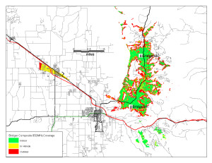
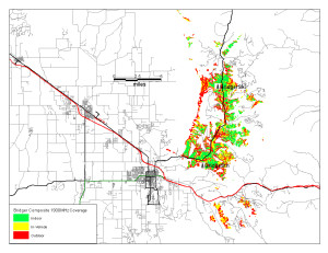
Then there are two “composite” maps that show coverage over the entire Canyon with Bridger Ski and Bridger South coverage mixed, at each frequency. Not sure why we didn’t get a map that shows both frequencies together over the entire canyon.

Remember that these maps are based on a 130′ tower at Bridger Bowl and a 150′ tower at the Brunners. Clearly, the taller the tower, the better the coverage. I understand from several sources that the BB Board is not considering the 130′ tower and wants to see something in the 60′ range. And I think it fair to say that an 150′ tall tower at the Brunners would elicit considerable local concern.

That being said, when you look at these propagation maps keep in mind this is a best possible scenario which is based on tower heights that are very unlikely to happen. [In particular, the 130′ tower at Bridger Bowl was a no-go with the board.] Hence, coverage will be less complete than what is shown. See Tierney’s comment below about tower height.*

Kent Madin

* “The primary goal is good coverage and tower height directly correlates to the quality and density of coverage in these locations where terrain issues place limitations on signal transmission.”

Composite850mhz Composite1900mhz

Composite coverage maps at 850 and 1900 MHz. Click to enlarge.

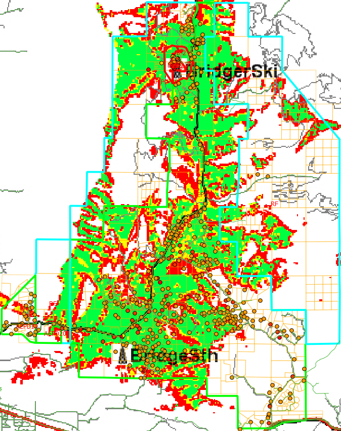
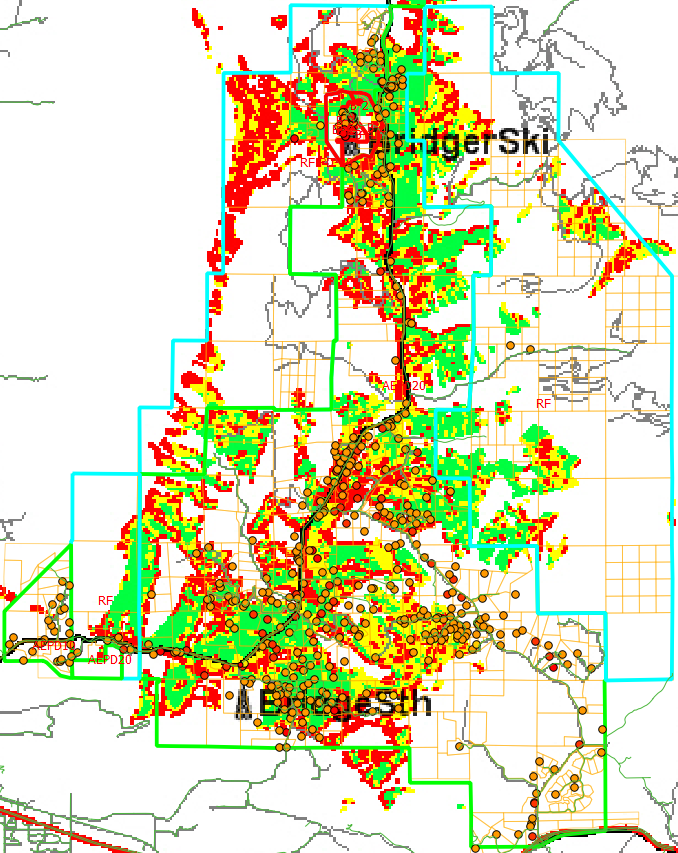
Update: Overlays of the coverage map with zoning district boundaries (blue), parcel lines (yellow) and structures (orange dots).

850MHz:

CoverageOverlay850mhz

1900MHz:

CoverageOverlay1900mhz

Bridger Canyon Natural History Evening, March 29

To the Residents of Bridger Canyon,

A number of people, in conjunction with the the Bridger Canyon Historic Preservation Association and the Montana Outdoor Science School (MOSS), have volunteered their time and expertise to enjoy and explore with Bridger Canyon residents an evening of “Bridger Canyon Natural History”. We would like to enhance this presentation with a display of photos or photos of artwork (no originals) from YOU, BC residents, which depict unusual/interesting natural history features of Bridger Canyon – geologic or water formations, birds, animals, plants both common and rare, etc.

This community event for Bridger Canyon residents will be at the Fire Station MARCH 29th, 7pm. If you have photos you’d like to contribute, please send them at your earliest convenience to:

Kathrin Olson-Rutz at : olsonrutz (at) netzero.net.

She will print 8 1/2X 11″ copies for the display. (You may also mail or deliver 8 ½ X 11” photos to MOSS, located at the Fish Hatchery). Please provide a few words that describe your contribution (what, general location, when) along with your name and contact information (email and phone number). This information will be printed out along with your photo to accompany your contribution. Feel free to provide several photos. We will display as many as we reasonably can. (No copyrighted material please.)

This spring, we would like to take the pictures we have printed out and assemble them into several “Bridger Canyon natural history notebooks” to be kept at the MOSS facility. These notebooks will be available to MOSS students and Bridger Canyon residents to identify and learn about Bridger Canyon plants, animals, water and geology. Residents are welcome to submit additional information specific to Bridger Canyon for these notebooks and can do so through MOSS.

For those unfamiliar with MOSS, it is dedicated to help children gain meaningful appreciation of the natural world around them through various educational projects (K-12 and some adult classes). MOSS takes the classroom to the field with trips to National Forest lands in Bridger Canyon, as well as to some private lands onto which they have been specifically invited for learning opportunities.

I hope you find this of interest! For more information, contact Ellen Trygstad (582-7624) eltjupiter (at) earthlink.net Thank you!

To the Residents of Bridger Canyon,

UPCOMING EVENT! A number of people, in conjunction with the the Bridger Canyon Historic Preservation Association and the Montana Outdoor Science School (MOSS), have volunteered their time and expertise to enjoy and explore with Bridger Canyon residents an evening of “Bridger Canyon Natural History”. We would like to enhance this presentation with a display of photos or photos of artwork (no originals) from YOU, BC residents, which depict unusual/interesting natural history features of Bridger Canyon – geologic or water formations, birds, animals, plants both common and rare, etc. 

This community event for Bridger Canyon residents will be at the Fire Station MARCH 29th, 7pm. If you have photos you’d like to contribute, please send them at your earliest convenience to: 

Kathrin Olson-Rutz at :  olsonrutz@netzero.net.

She will print 8 1/2X 11″ copies for the display. (You may also mail or deliver 8 ½ X 11” photos to MOSS, located at the Fish Hatchery). Please provide a few words that describe your contribution (what, general location, when) along with your name and contact information (email and phone number). This information will be printed out along with your photo to accompany your contribution. Feel free to provide several photos. We will display as many as we reasonably can. (No copyrighted material please.)

This spring, we would like to take the pictures we have printed out and assemble them into several “Bridger Canyon natural history notebooks” to be kept at the MOSS facility. These notebooks will be available to MOSS students and Bridger Canyon residents to identify and learn about Bridger Canyon plants, animals, water and geology. Residents are welcome to submit additional information specific to Bridger Canyon for these notebooks and can do so through MOSS.

For those unfamiliar with MOSS, it is dedicated to help children gain meaningful appreciation of the natural world around them through various educational projects (K-12 and some adult classes). MOSS takes the classroom to the field with trips to National Forest lands in Bridger Canyon, as well as to some private lands onto which they have been specifically invited for learning opportunities.

I hope you find this of interest! For more information, contact Ellen Trygstad (582-7624) eltjupiter@earthlink.net   Thank you!

Commissioner Murdock Resigning

County Commissioner Bill Murdock will be resigning next month. He will surely be missed in Bridger Canyon. He has often been a lonely voice on the commission in favor of the good land use planning that has kept the Canyon beautiful. From the Bozeman Daily Chronicle:

Editorial: Murdock was county’s voice for responsible planning

Posted: Sunday, March 17, 2013 12:15 am

The departure of retiring Gallatin County Commissioner Bill Murdock next month will mark the end of an era. For 16 years, Murdock has been a voice of moderation in what tends to be a conservative office.

County commission elections are dominated by the rural vote, which tends to be quite conservative on land-use and planning issues. And that vote is rarely overcome by the pro-planning faction among the county’s only real urban voters in Bozeman.

Murdock has long battled the headwind of those conservative tendencies. He has contributed heavily to successes in land-use planning and regulation as well as open-space preservation. He has also been a stalwart enforcer of policy in the face of frequent and well-financed challenges from real estate developers.

That influence will be missed.

Murdock’s term doesn’t end until the end of next year. His resignation triggers a process that will name his replacement on the commission – a person that will take the advantage of incumbency into the 2014 election.

law, the remaining two commissioners, Republicans Steve White and Joe Skinner will name Murdock’s successor from a field of three candidates suggested by state GOP leadership because Murdock is also a Republican.

Murdock’s departure and the process for replacing him have the potential to push the commission hard to the right. And that would not bode well for the future of some land-use issues in Gallatin County.

Republican leaders and White and Skinner are urged to consider all the county’s constituents as they appoint Murdock’s replacement. Filling the seat with another advocate for land-use planning and open-space preservation will maintain a healthy balance on the commission and stimulate vigorous debate on these very important issues.

Quality of life is what has drawn many immigrants to Bozeman and Southwest Montana. A big part of that quality of life is the open countryside and expansive views of our rural areas. And the County Commission plays a major role in preserving those amenities.

Choose Murdock’s replacement carefully. Find another powerful voice for smart planning and open-space preservation.

Lessons from the Theken Barn

Two years of administrative and legal wrangling came to an end recently when the Montana Supreme Court told Randy Theken to remove his half-built barn below the “M.” This was an affirmation of both law and common sense.

To the residents of Bridger Canyon who invested their time and money to defend the zoning regulations in this matter, congratulations, your efforts were well spent and much appreciated. To the four members of the Bridger Canyon Zoning Commission (BCZC) who reviewed the facts, listened to the community and voted that the barn must be removed, thanks for standing with your regulations and your constituents. Thanks to Judge Salvagni, who affirmed the decision by the commission. And thanks to the Montana Supreme Court who saw the issue clearly in spite of what the court characterized as Mr. Theken’s efforts “to complicate an otherwise straightforward question.”

When a legal question winds its way all the way up to the Supreme Court, there should be some lessons learned beyond the details of building permits and “building envelopes,” lessons that strengthen the community.

First and foremost, is the simple maxim “Rules are rules.” If you can’t or won’t enforce rules, don’t make them. If it is your job to enforce existing rules, do it in an efficient, consistent and timely manner. After-the-fact administrative sleight of hand that forgives broken rules only encourages the breaking of rules in the first place. Much expense for all parties would have been avoided by Mr. Theken’s applying for a permit before starting his barn or working with the BCZD and his neighbors on a location or design that met the regulations. By proceeding solely on his own authority he has had to dismantle his barn.

“Well-conceived and strongly enforced land use planning is essential” said the Montana Supreme Court in 1995 when the court found in favor of Bridger Canyon Property Owners Association (BCPOA) when the property owners objected to higher than allowable density in the Bridger Bowl base area.

Perhaps this is a good opportunity for our organization, BCPOA, to cut through the jargon of planning and zoning and explain to Gallatin County residents just what we see is at stake in these zoning issues for both the residents and non-residents who enjoy the Canyon.

BCZD was created by grass-roots citizen petition 41 years ago to oversee an orderly and predictable process of development while fiercely guarding the qualities (water, air, wildlife, agricultural use, rural lifestyle) that define the ambiance of the Canyon and preserve the property values of those of us who live there. It has done a pretty fine job so far. For the second time in as many decades, the Montana Supreme Court has affirmed the core values and integrity of Bridger Canyon Zoning District.

Each of those Supreme Court cases, when you clear away the details, comes down to one simple concept: density. Here’s what the Master Plan said in 1971 (and still says, loud and clear, in 2012): “Agricultural preservation is a primary goal which is to be accomplished by limiting development to one housing unit per 40 acres, and providing for higher density under planned unit developments. The forty (40) acre minimum lot size is based on limiting population so that the capacity of the two (2) lane highway is not exceeded.”

In other words, once growth demands a widened road the rural and natural qualities of Bridger Canyon will be lost.

For the last several months a long overdue update of the Bridger Canyon Zoning Regulations has been underway. Reaffirming the original density restriction should remain the paramount objective – it goes right to the bottom line of property values. But over the last few years residents have seen indirect calls for higher density through a variety of dubious machinations and interpretations of the regulations. For both residents and those who travel the Canyon or recreate there this presages a gradual diminution of the space, the quiet, the wildlife and the vistas.

We look forward to working with the professionals in planning and our elected representatives in developing and enforcing a streamlined set of regulations that reaffirms and defends the core principle of density limitation, the clear intention of those who established the first zoning district in the State of Montana.

Kent Madin and Richard Lyon wrote this on behalf of the board of directors of the Bridger Canyon Property Owners Association.

[google-map-v3 width=”350″ height=”350″ zoom=”12″ maptype=”hybrid” mapalign=”center” directionhint=”false” language=”default” poweredby=”false” maptypecontrol=”true” pancontrol=”true” zoomcontrol=”true” scalecontrol=”true” streetviewcontrol=”true” scrollwheelcontrol=”false” draggable=”true” tiltfourtyfive=”false” addmarkermashupbubble=”false” addmarkermashupbubble=”false” addmarkerlist=”45.709427° -110.985211°{}1-default.png{}Theken barn” bubbleautopan=”true” showbike=”false” showtraffic=”false” showpanoramio=”false”]

Density Survey Results

Thanks to everyone who responded to the density survey.

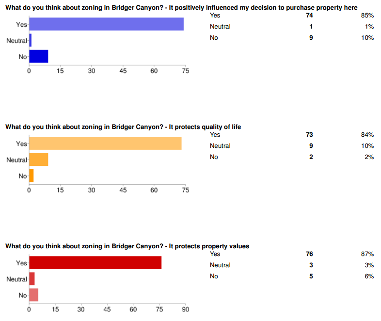
Detailed results are here: BCPOA Density Survey A sample:

DensitySurveyCapture

Comments are open on this post, which is probably the easiest place to discuss the results without putting too much traffic on this email list.

The spreadsheet of complete answers is here:

https://docs.google.com/spreadsheet/ccc?key=0Arh9sK-JAE8NdE1BQ0tYYkRpYUVlNHJ

The short answer appears to be that 85% of you think the current density is 1 residence per 40 acres, and over 80% think it should stay that way or become less dense. The 19 respondents who reported owning more than 40 acres (up to a few hundred) were even more certain about this (approaching 95%) than the 51 owners with 40 or fewer acres. About 40% think density should be 1-in-40, period, while another 40% would permit density transfers. A smaller minority would provide a modest density bonus in exchange for good design, while only one person out of 85 expressed interest in a double-density bonus.

Several people commented to the effect of, “why does BCPOA want to fix what isn’t broken?” There are three answers to that.

First, a number of things are broken. There are many ambiguities in the drafting of the current regulation. Ambiguity leads to a lot of needless controversy in the permitting process. An example: the PUD regulation requires an applicant to have terrain and vegetation suitable for minimizing the visual impacts of homes, but the standards don’t require you to use that terrain and vegetation. Confronted with such ambiguity, the commission doesn’t make a sensible interpretation with the General Plan in mind; it instead grants a large density bonus with no discernible community benefit, which is why we have a few PUDs with homes on exposed slopes and ridgelines.

Second, the zoning can’t remain completely static, even if we want it to, because the county has set updates in motion. For example, the commission independently proposed a draft update to the administrative section of our zoning, which gutted our enforcement provisions (as if enforcement weren’t already problematic). Deflecting such initiatives, while responding to the county’s need for administrative consistency, is important.

Third, while 80% of you think that the density is and should be 1-in-40, that’s not current practice. The county has granted density in excess of 1-in-20 through PUDs, via a combination of density bonuses and even transfers off theoretical bits of land that aren’t legal parcels. Further, the commission has granted caretaker residences without restrictions, which in effect make every parcel a two-residence unit. Combining the two, the real potential density is up to four times 1-in-40.

This is not how things originally worked. In 1971, the zoning regulation provided underlying density of 1-in-40 acres, and a PUD density up to 1-in-20 acres. However, the higher PUD density was to be achieved through transfers from areas less suitable for development. The only mention of a density bonus was a modest 30% for development in areas deemed particularly suitable. There was no provision for caretakers (though there has always been agricultural employee housing). Unfortunately the drafting of the original regulation wasn’t crystal clear. Subsequent amendments and ongoing ambiguity led to the prevailing interpretation of PUD density as a bonus (almost a giveaway). The county quit keeping track of density transfers more than 15 years ago, as they no longer serve much purpose. (I would be interested to hear the stories of people who were around at the beginning or along the way; I wasn’t quite in diapers at the time, but have to rely on reading old documents.)

That’s why we need to know what people want. Do we codify the commission’s current practices, and change the vision in the General Plan to reflect the higher density, or do we try to improve the Zoning Regulation so that it better implements the Plan, restoring something closer to 1-in-40, with clear objective standards for any transfers or bonuses in PUDs?

Thanks again for all your input.

Detailed written comments are below the fold: Continue reading

Enforcement Survey Results

Thank you all who responded by email or on our survey form. I’ve posted responses as of 4/6/2010 here:

https://spreadsheets.google.com/pub?key=tFXvv9Szp2ftATRDioInxcQ&single=true&gid=1&output=html

Briefly, the responses are overwhelmingly in favor of strong zoning enforcement. At least 90% of responses said something like,

  • “We must insist that the county follow the rules.  It is not fair to property owners to allow violations that can obstruct our valuable views and reduce the value of our properties.”
  • “Although I would like to be lenient, the problem is that each infringement sets a precedence that creates a new standard. … I see no practical possibility of selectively enforcing the ordinances.”
  • “We have to be aggressive, or we might as well just forget the zoning.”

Many identified a teardown as the appropriate response. Several suggested legal action against the county if the enforcement response was inadequate.

Two responses expressed ambivalence about enforcement and enthusiasm for barns, as in:

  • “We can’t help but feel that it’s a sad commentary when barns are this controversial in Montana. We have never felt that a barn detracted from the landscape and if this was to actually be a barn in the traditional sense, it seems wrong to deny the horses on this property a shelter.  Was it just the placement of the barn that was at odds with the regulations?”

The issue with this barn is indeed placement, but also procedures. The structure would be acceptable within the building envelope designated for the site, but even so it is not acceptable to build without a permit. (Had the builder sought a permit, the current situation could have been avoided.)

I don’t think anyone wants to waste resources with a teardown. However, it’s important to remember that exceptions have wider repercussions. The zoning does not distinguish between good architecture and a lime green metal building, or between a 1700 sq ft barn and a 7100 sq ft arena. A modest exception in one place could set a precedent for a disaster somewhere else.

The beauty of a barn vs. the curve of a ridge may be in the eye of the beholder, but there’s more than views at stake here. Building envelopes are also intended to protect open space for wildlife, watercourses, and other natural resources.

If this were an ordinary lot in the canyon, there would be few site restrictions. However, this is a PUD. At the underlying density of one dwelling per 40 acres, there could be two dwellings on the 100 acres in Brass Lantern, but the PUD provided five. That’s a huge density bonus, easily worth more than a million dollars today. The price for that added density is supposed to be development of better quality and location of density in more appropriate areas, hence the building envelopes and other restrictions. The density is permanent, so the restrictions should be permanently enforced if the deal is to be fair to all of us.

As several responders pointed out, if zoning is not enforced it might as well be repealed – that would at least be fairer to those who follow the rules. Allowing PUD density everywhere would have a profound effect. Fully built out at the underlying zoning of one-per-40 acres, the canyon could already triple in population to over 1300 households, becoming bigger than Big Sky is today. At the PUD density of 1-in-20, there could be nearly two Big Skies.

Future density is probably the most fundamental question that the upcoming zoning update must address. As the process gets going, we’ll be seeking your input about future visions for the canyon.

Thanks again for all the responses – this will be excellent support for our efforts to get the county to take meaningful action.