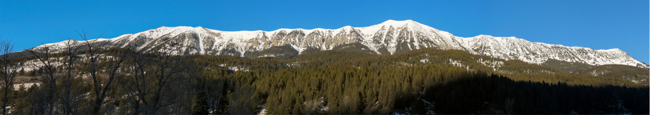
We’ve added a page of resources on dark-sky compliant lighting. Take a look!
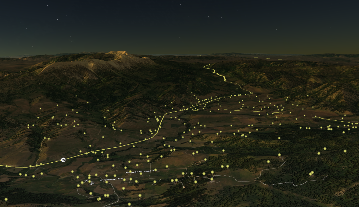
Bridger Canyon in the evening, as simulated by Google Earth. Each glowing orb represents a single light on an existing structure.
We’ve added a page of resources on dark-sky compliant lighting. Take a look!
Bridger Canyon in the evening, as simulated by Google Earth. Each glowing orb represents a single light on an existing structure.
We’ve supplemented the Zoning information page with a list of resources for getting in touch with County departments and commissions, and submitting testimony to hearings. Check it out!
The bottom line appears to be that Canyon email list members strongly oppose repeal of 14.2:
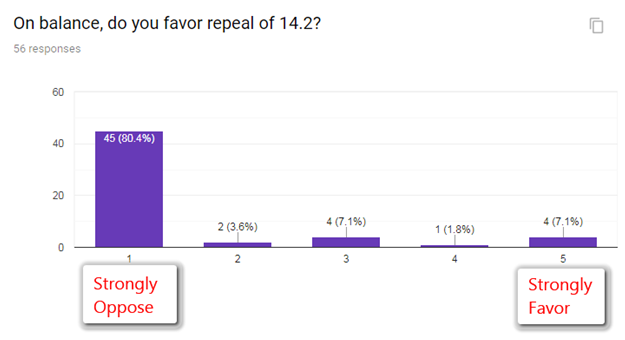
The full results are here:
The Planning Department proposes to repeal section 14.2 of the BC zoning regulation:
14.2 Building Sites Which do Not Conform to the General Regulations.
a. In any district, notwithstanding other limitations imposed by this Regulation, structures permitted in said district may be erected on any single lot of record on the effective date of this Regulation. Such lot must be in separate ownership. A lot of record that does not meet lot area or lot width requirements must still meet other requirements of the district. If two (2) or more lots and portion of lots with continuous frontage in single ownership are of record at the time of adoption or amendment of this Regulation, and if all or part of the lots do not meet the requirements established for lot width and area, the lands involved shall be considered to be an undivided parcel for the purposes of this Regulation. Where lots are larger than required by this Regulation, said lots may be subdivided into smaller lots except no parcel may be divided so as to create a lot smaller in lot width or lot area than required by this Regulation. [Emphasis Added.]
This provision reduces the density rights of small parcels that were adjacent and under the control of a single owner as of the inception of zoning in 1971. This is fairly common in other jurisdictions, and has been widely upheld in the courts (see Gallik testimony for BCPOA below). It appears in at least one other Gallatin County zoning regulation.
If repealed, building rights spring into existence on some number of lots that have not had them since 1971, with attendant side effects for neighbors and density. Repeal also resolves a complaint, arising from the county’s issuance – in error – of a land use permit for a house on a very small, narrow lot along Bridger Canyon Rd.
No one knows exactly which or how many parcels are affected, because it is difficult to determine common ownership as of 1971 en masse. A title search is required in each case. See also: maps of potentially affected parcels.
| Supporting Repeal | Opposing Repeal (BCPOA Position) |
| It’s a taking. | It’s not a taking, according to the Supreme Court and many local jurisdictions. |
| All parcels of record should have a development right. | Elevation of lot lines above all other considerations has not been supported by the courts. |
| In 1971, people understood that all parcels would have development rights. | In 1971, the original zoning regulation included language very similar to 14.2. |
| Some owners benefit from developing their parcels. | Adjacent owners who relied on these parcels not developing are harmed. |
| It’s hard to administer. | The zoning does not exist for the convenience of administrators, and there may be other remedies than repeal. For example, the draft Admin regulations put the burden of proof for nonconforming parcel development on the owner. |
| It’s inconsistent with other districts. | At least one other, Sypes Canyon, has the same provision. |
| Some lots subject to the regulation have already been sold separately or developed. | This may have happened, but it is water under the bridge. No specific instances are known. |
| There’s no visible notice to prospective buyers, e.g., on plat maps or deeds. | This is true of many aspects of zoning. |
| Some small parcels are treated differently from others, on the basis of common ownership. | Equal protection is for people, not parcels. |
| Repeal does not conflict with the General Plan. | Repeal increases density, and keeping low density is clearly the primary goal of the General Plan. 14.2 was clearly a part of the original implementation of the General Plan. |
| It’s part of the standardization of administration. | Administration should not be one-size-fits-all where it affects the substantive provisions of the zoning. |
| Limited staff resources will be required to defend this provision. | Limited staff resources are required to defend every provision of the zoning; why single out this one? |
| It’s ambiguous, resulting in different interpretations by different people. | There is no evidence that this is a practical problem. |
| Parcels that were considered de facto merged become developable, having evaded separate taxation for decades; this is unfair for others who have carried the burden of taxation in the interim. | |
| It’s not spot zoning. | It is clearly motivated by a single complaint. |
| Repeal would minimize the probability of staff errors and litigation. | Since parcels potentially subject to 14.2 have now been identified, this is a much smaller risk in the future. In addition, the county’s own proposed administrative regulations provides a good way to handle nonconforming parcels, shifting the burden of proof to the builder. |
The 1971 Zoning Regulation – see section 9.2 for the language corresponding to 14.2 today: OrigRegsMerge.pdf
The 1999 regulation, containing section 14.2 as it reads today: regulations_012699.pdf
The Planning Department Staff Report for the Feb. 14th hearing: Bridger_ZTA_2.14.19_P&Z_Packet.pdf
BCPOA testimony on previous 14.2 proceedings:
From Richard Lyon: BCPOA-14.2.ProcessComparison.190124.pdf
From attorney Brian Gallik: BCPOA-Kensey.GallickSubm.190103.rgl.pdf
On Feb. 14th, the Planning & Zoning Commission approved the repeal, over the objections of a majority of written and oral testimony. The amendment passes next to the County Commission for ratification.
Testimony that arrived in the last few days before the hearing:
public comment 1 of 2.pdf
public comment 2 of 2.pdf
A transcript of the hearing:
Transcript Planning_and_Zoning_Commission_2019-02-14_09-30-31_AM.pdf
The maps that follow are not definitive; they only indicate parcels that might be subject to 14.2, and the determinations are not necessarily exhaustive.
The BCPOA map identifies small parcels that are not in known subdivisions, but does not check for common ownership as of 1971, which is what counts for the regulation.
The County map shows parcels in common ownership as of today. Ownership today is not the decision criteria for density rights in 14.2, so this is only relevant to the extent that ownership today is indicative of ownership in 1971.
Unfortunately, digital records only go back to the mid-1980s, so it’s difficult to improve on this, except by manually searching the titles for a particular parcel.
Here’s a pair of maps of parcels potentially affected by the repeal of 14.2:
BCPOA identified 134 undeveloped parcels under 36 acres, most of which are adjacent, but we have not investigated ownership as of 1971. Therefore these parcels overestimate the impact of 14.2:
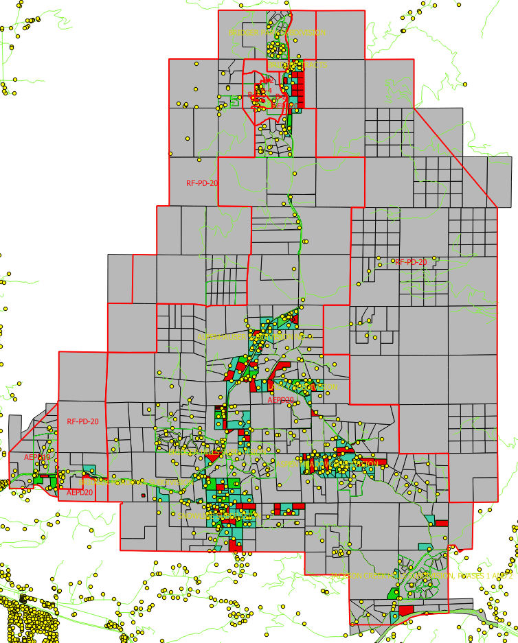
Above, small parcels that might be affected, if they were in common ownership as of 1971, are colored green (if they now have a structure, according to GIS data) and red (if they are undeveloped).
Separately, the Planning Department identified small parcels in common ownership. Their methods are described in Section14.2_GIS Analysis.MEMO. This map omits several parcels that we know to be subject to 14.2, so we suspect that it underestimates the extent of the impact. [It turns out that the omitted parcels were obscured by road lines; the county showed a revised map that revealed the missing parcels.]
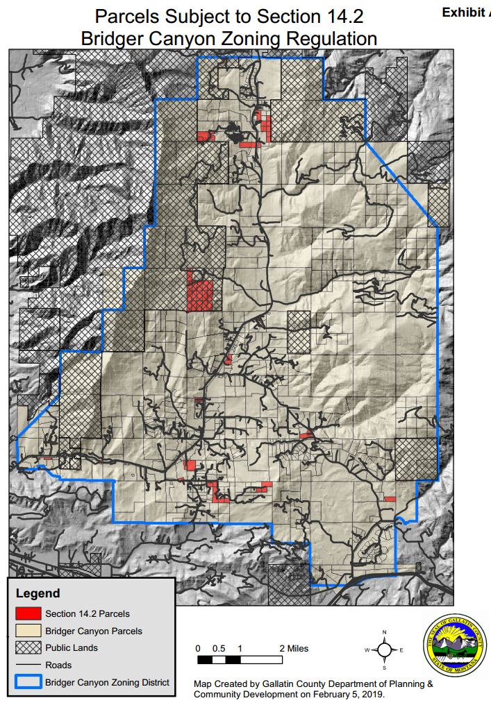
Presumably, the true impact lies somewhere between these two maps – probably closer to the county version.
Further reading: 14.2 Repeal – Background


 Twitter
 Facebook
 RSS
RSS Email
Email